
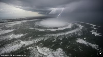
The Bay of Bengal is facing another spell of severe weather as Cyclone Akvan develops following two recent storms, Arnab and Murasu, that affected India’s eastern coastline. The rapid succession of weather systems has raised concerns about coastal safety, agricultural losses and the unusual concentration of cyclone activity in a short period.
The India Meteorological Department (IMD) reported that Akvan formed over the central parts of the south and adjoining west-central Bay of Bengal on November 16, 2026. The system is forecast to strengthen further and move towards the Andhra Pradesh coast, with the possibility of becoming a very severe cyclonic storm.
The renewed activity highlights a familiar feature of the post-monsoon season: the Bay of Bengal can remain favourable for tropical cyclone formation well into November and December, when warm ocean waters and suitable atmospheric conditions allow storms to develop.
Why Are Cyclones Forming So Close Together?
Cyclones typically need several environmental conditions to develop and intensify. These include warm sea-surface temperatures, sufficient moisture, atmospheric instability and relatively weak vertical wind shear, which allows a storm to maintain its organised structure.
The Bay of Bengal often retains substantial heat after the southwest monsoon. Warm water supplies the energy that helps low-pressure systems grow, while moist air supports the thunderstorms that form around a cyclone’s centre.
The post-monsoon period is particularly favourable because the atmospheric circulation begins to change after the monsoon retreats. When wind patterns and moisture conditions align, disturbances can strengthen rapidly.
However, consecutive cyclones are not guaranteed simply because the sea is warm. A powerful storm can churn up cooler water from below, leaving a temporary cold wake that reduces the energy available to a following system. Changes in atmospheric winds can also make the environment less favourable.
The formation of another cyclone therefore depends on the precise location of each system and whether favourable conditions persist in other parts of the Bay.
Why the Bay of Bengal Is Particularly Cyclone-Prone
The Bay of Bengal is bordered by land on three sides, and its coastal geography can influence how storms move towards India, Bangladesh and Myanmar. The basin also receives substantial freshwater from major rivers, contributing to ocean conditions that can affect how heat is distributed near the surface.
Warm ocean water is a key source of energy for tropical cyclones. When moist air rises and condenses into clouds, it releases heat into the atmosphere, helping the storm’s circulation strengthen.
The October–December post-monsoon period is one of the two main cyclone seasons in the North Indian Ocean. During this period, the Bay can combine warm sea temperatures with favourable wind patterns, allowing several weather disturbances to develop in succession.
Scientists have noted that Arnab and Murasu formed in different parts of the Bay. This matters because a cyclone’s effects on ocean temperatures and atmospheric circulation may be concentrated around its own track, leaving other areas capable of supporting a new system.
What Happened With Cyclones Arnab and Murasu?
Cyclone Arnab struck the Andhra Pradesh coast on October 28, followed by Cyclone Murasu, which crossed the coast near Ongole on November 3 as a severe cyclonic storm.
Murasu brought strong winds and heavy rainfall before weakening over land. The back-to-back storms disrupted transport, damaged infrastructure and affected agricultural areas, leaving communities with limited time to recover before the next system developed.
The short interval between the storms was unusual because a powerful cyclone typically disturbs the ocean and atmosphere in ways that can temporarily make the formation of another cyclone more difficult.
However, the sequence does not necessarily mean the entire Bay of Bengal is experiencing an unprecedented change. Establishing whether this season is part of a longer-term climate trend requires analysis of historical cyclone records and ocean conditions.
How Strong Could Cyclone Akvan Become?
As of the IMD’s November 16 evening bulletin, Akvan was forecast to intensify into a severe cyclonic storm around November 17 and potentially become a very severe cyclonic storm by November 19.
The department projected that the system could cross the Andhra Pradesh and Yanam coasts between Nellore and Tuni around midday on November 20, with sustained winds of 120–130 kmph and gusts reaching 145 kmph. These were forecasts, and the system’s actual path and intensity could change.
Authorities were monitoring the storm because strong winds and heavy rainfall could damage houses, uproot trees, disrupt electricity and transport, and threaten crops. Fishermen were advised to follow official warnings as sea conditions deteriorated.
The impact will depend not only on wind speed but also on rainfall intensity, storm movement, coastal exposure and the preparedness of local administrations.
Why the Name Akvan Was Chosen
Akvan is the next name in the regional naming sequence for tropical cyclones and was contributed by Iran. The name is associated with a supernatural adversary in Persian mythology and the epic Shahnameh.
Cyclone names are selected from an approved list maintained through the World Meteorological Organization and the United Nations Economic and Social Commission for Asia and the Pacific. The names are used in sequence; they are not selected according to the country a storm is expected to strike.
The IMD assigns a name once a system reaches the required cyclonic-storm intensity. Naming helps authorities and the public distinguish one storm from another and communicate warnings more clearly.
What the Repeated Storms Mean for Coastal Communities
The succession of Arnab, Murasu and Akvan underlines the importance of preparing for multiple storms within a single season. Communities recovering from one cyclone may face damaged homes, weakened infrastructure and agricultural losses when the next warning arrives.
Early evacuation planning, reliable weather alerts, secure shelters and protection for livestock and essential supplies can help reduce the danger. Coastal residents should follow updates from the IMD and local disaster-management authorities rather than relying on predicted landfall locations alone.
The underlying reason for repeated cyclone formation is a combination of seasonal ocean heat, moisture and favourable atmospheric circulation—not simply the fact that one storm has followed another. Akvan’s development shows how quickly conditions over the Bay of Bengal can change, making continuous monitoring and timely preparation essential.