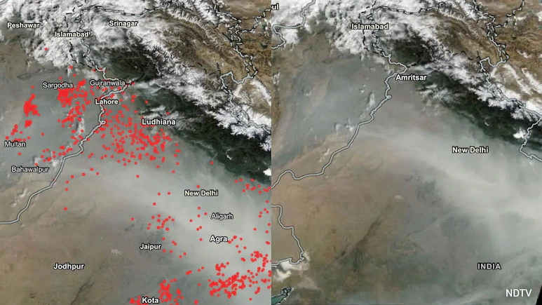
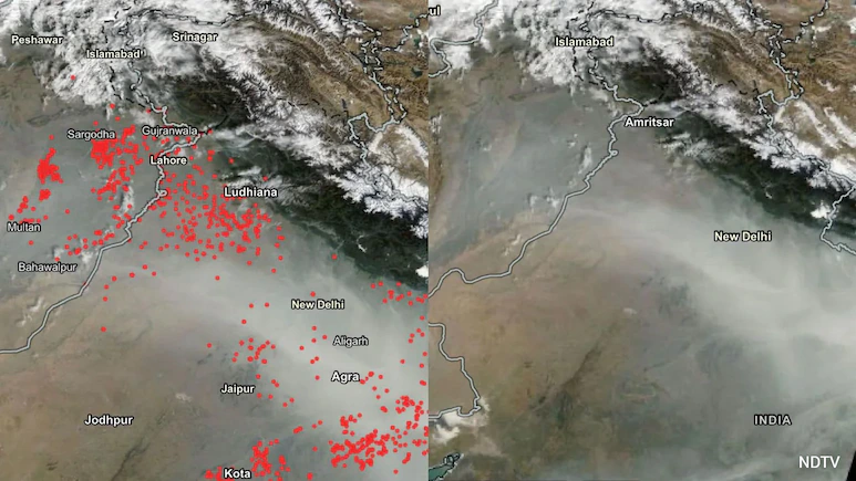
India’s efforts to monitor stubble burning in Punjab and Haryana are facing a technological challenge as some farmers are reportedly taking advantage of gaps in satellite surveillance to burn crop residue without being detected. The issue has raised questions about whether the decline in officially recorded farm fires reflects the full extent of the problem.
The situation has drawn comparisons with India’s 1998 Pokhran nuclear tests, when scientists working under the leadership of Dr APJ Abdul Kalam concealed preparations from foreign surveillance satellites. Today, the challenge is different, but it highlights a similar limitation: satellites cannot continuously observe every location unless the monitoring system is designed to provide near-constant coverage.
To address these gaps, the environmental research organisation International Forum for Environment, Sustainability and Technology (iFOREST) has developed a multi-satellite monitoring platform called Fire Watch. The system aims to provide a more complete picture of farm fires by combining observations from different satellites and assessing the land affected by burning.
Why Conventional Satellite Monitoring Can Miss Farm Fires
India’s existing farm-fire monitoring relies heavily on polar-orbiting satellites that pass over particular locations at scheduled intervals. These systems use sensors such as NASA’s Moderate Resolution Imaging Spectroradiometer (MODIS) and the Visible Infrared Imaging Radiometer Suite (VIIRS).
The satellites provide valuable information about active fires, but their observations are not continuous. If a fire starts and burns between observation windows, it may not appear in the daily satellite-based count.
Experts have raised concerns that some farmers have become aware of these limitations and may be changing when they burn crop residue. Consequently, a lower number of recorded incidents does not necessarily mean that the actual number of fires has fallen by the same proportion.
This creates a challenge for authorities trying to assess the effectiveness of enforcement measures and determine the contribution of stubble burning to seasonal air pollution.
Fire Watch Combines Data From Multiple Satellites
Fire Watch has been developed to overcome the limitations of relying on a small number of satellite observations. The platform brings together information from several satellite systems to improve the detection and assessment of agricultural fires.
Its monitoring approach includes three key components:
- Active fire detection: MODIS and VIIRS data help identify fires detected during satellite observations.
- More frequent observations: Meteosat-8 and Meteosat-9 use the SEVIRI instrument to observe the same region repeatedly, providing imagery at intervals of approximately 15 minutes.
- Burnt-area assessment: Sentinel-2 imagery can be compared before and after the burning season to estimate the extent of farmland affected by fires.
The combination helps researchers examine not only how many fires are recorded, but also when they occur and how much agricultural land has been burned.
iFOREST chief executive Chandra Bhushan has emphasised that policymakers need a more comprehensive understanding of the location, timing and extent of farm fires to design effective interventions.
Recorded Farm Fires Have Fallen Sharply
Officially detected farm-fire incidents have declined significantly in recent years. The reported count fell from nearly 80,000 incidents in 2021 to around 6,000 in 2025.
Several factors have contributed to the decline, including enforcement measures, penalties, machinery subsidies and awareness campaigns. However, experts have also questioned whether changing burning patterns and gaps in satellite observation could mean that some incidents are being missed.
The distinction matters because fire counts alone cannot provide a complete measure of the environmental damage. Two areas with similar numbers of detected fires may have very different amounts of land affected.
More comprehensive monitoring could help governments distinguish between genuine progress in reducing stubble burning and apparent improvements caused by limitations in detection.
Parliament Calls for Better Fire Surveillance
The monitoring challenge has also drawn attention at the parliamentary level. A Parliamentary Standing Committee in 2026 highlighted gaps in the observation of forest fires and other environmental events, recommending that India prioritise the development of a geostationary satellite capable of monitoring fires around the clock.
Unlike polar-orbiting satellites, which periodically pass over a location, geostationary satellites remain positioned to observe the same broad region repeatedly. Such systems could significantly reduce the periods during which fires remain undetected.
India has technological capabilities that could support this approach, but making the data available for environmental monitoring remains an important consideration.
Can India’s EOS-05 Improve Monitoring?
India’s EOS-05, also known as GISAT-1A, is designed to provide repeated observations of the country. The satellite could potentially support environmental surveillance by allowing selected regions to be observed at frequent intervals.
However, the satellite was still undergoing in-orbit testing at the time of the report. Its strategic role and operational arrangements also raise questions about how readily its observations can be accessed by civilian agencies responsible for air quality and agricultural monitoring.
Scientists have argued that relevant satellite data should be made available for environmental applications wherever possible, particularly when it could help address serious public-health concerns.
Burnt Fields Can Still Reveal Undetected Fires
Even when satellites fail to capture an active fire, the damage left behind can provide evidence of burning.
India’s National Remote Sensing Centre uses satellite imagery, including high-resolution Cartosat-3 data, to assess burnt agricultural areas. These assessments can help authorities identify locations where crop residue has been burned even if the flames were not recorded during an observation window.
The resulting information is shared with the Commission for Air Quality Management, which oversees efforts to address pollution in Delhi-NCR and surrounding regions.
This approach offers an important complement to conventional fire detection: monitoring the aftermath can reveal activity that escaped direct observation.
Better Data Is Essential to Tackling Air Pollution
Stubble burning remains a major concern during the post-harvest season, when smoke from agricultural fires can contribute to deteriorating air quality across northern India. Effective action requires reliable information about the scale and timing of burning, alongside practical alternatives that allow farmers to manage crop residue.
Improved satellite coverage, burnt-area analysis and monitoring on the ground could give authorities a clearer picture of the problem. But technology alone will not eliminate the practice. Enforcement, access to affordable machinery, farmer support and viable crop-residue management options will remain essential.
The emerging challenge is therefore not simply to count fewer fires, but to establish whether fewer fires are actually taking place. More comprehensive monitoring could help India measure progress accurately and design more effective strategies to reduce stubble burning and its impact on air quality.